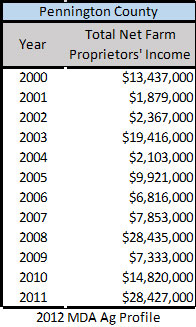
The table below reflects the farm income from 2000-2011.
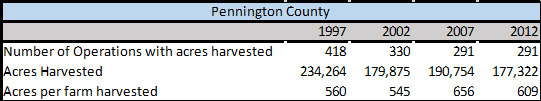
The table below reflects the decrease in number of farms within the County, along with a general increase in acres per farm
harvested over the years of 1997-2012. It must be remembered
that a good deal of Conservation Reserve Program acreage has come back into crop production since 2012, which would increase the acreage per farm even more.
County Economic Trends
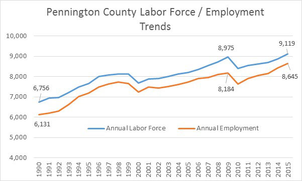
Employment in the County shows significant gains over the past decade and still continues to be relatively strong. Unemployment in Pennington County is 4.3% as of August 2016. The recent downturn over the past two years in the farm economy is softening land values somewhat. However, the rapid growth of the regional economy over the past few years was mostly attributable to manufacturing and agriculture sectors.
Topography and Natural Resources
Smiley Township is located in the central part of Pennington County. It is bordered on the north by Silverton Township, on the west by Rocksbury Township and City of Thief River Falls, on the south by Wyandotte Township and River Falls Township, and on the east by Kratka Township.
The topography of the township is the result of glacial activity. Generally the area is relatively flat with some slight fluctuations—basically, flat to gently sloping. The eastern two-thirds of the county is a nearly level glacial plain. The calcareous glacial till is commonly loam or clay loam, mostly poorly drained, with small stones or pebbles scattered over the surface. There are many depressions and narrow drainageways.
Attached is a soils map of Smiley Township. One feature of the soils which is important in the planning process is the ability to support on-site sewage systems. The problems included backup of wastes into the house, odorous waste surfacing at the tile field, and backup of waste and odorous water. These problems reflect the fact that some of the soils found in Smiley Township have one or more properties which are unfavorable for sewage systems, and thus require a special design or maintenance. Soil restrictions have important implications for future development in the Township. Consequently, soil conditions and limitations must be seriously considered as one important element in land use control.
Land Use
The historical land use in Smiley Township included lumbering but was rapidly replaced by farming in the late 19th and 20th centuries. Most of the native vegetation of the county is generally divided into two types—tallgrass prairie and mixed
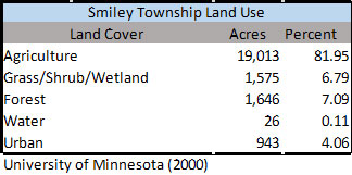
hardwood forests. West of the Red Lake and Thief Rivers, the soils developed under tallgrass prairie, while east of those rivers and on the beach ridges of Glacial Lake Agassiz, the soils developed under mixed hardwood forest or savanna vegetation. The land is suitable for farming and pasture, with some cattle and sheep raised in the township.
There is limited commercial development in Smiley Township. What commercial establishments there are can be found along the US Hwy 59 corridor southeast of Thief River Falls, but mostly residential dwellings predominate. Future development of commercial enterprises in the Township must be addressed, not only as to where commercial activity should be located, but also with respect to the nature and type of commercial development desired. Regulation of housing developments and junkyards are two types of development which this land use plan will attempt to address.
Housing
Smiley Township housing includes both occupied and vacant dwellings. According to the 2010 Census data, there were a total of 217 housing units, 194 of these were occupied and 23 were vacant. The age of housing reflects relatively newer buildings, with more than 75% of housing units built after 1960. Approximately 25% were built before 1960.
One of the problems associated with housing that has taken place previously in the township include manufactured housing developments that have fallen into decay or disrepair, some with compromised sewage systems, and/or with rubbish and long grass in the yards. The susceptibility to rodents and overall undesirable appearance is an issue. The township has no regulations establishing minimum size, skirting, type of foundation, or other requirements designed to protect substandard housing within the township.
Transportation
The private automobile remains the primary mode of township transportation. US Hwy 59 is the major, paved all weather thoroughfare, along with other paved and graveled county and township roads. US Hwy 59 is a ten ton freight corridor and provides relatively quick access to Thief River Falls and to the regional airport. Hwy 59 is also a major route to connections with US Hwy 10, I-94, and to the Canadian Border. The annual average traffic count on Hwy 59 indicates a major freight route, and also a tourism corridor for traffic to Seven Clans Casino located just to the south of Smiley. Generally, the transportation system is good in Smiley Township.

9. Summary
Major development patterns affecting the township include:
- Township population is gradually rising since 1990, growing an average of 10-15%.
- The Township is affected by agricultural trends, including recent and long-term trends towards fewer full-time farmers and larger operations.
- Employment changes in Thief River Falls appear to have a dramatic effect on Township population.
- Growth in indicated market value points to a strong property tax base and a positive economic outlook at least for the near future.
- It is likely the township will continue to gradually add to its population as long as the TRF economy remains strong, but the composition of the population is likely to change based on trends in farm size and job growth in TRF.